


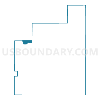
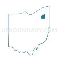
Voting District Chester Twp B, Geauga County, Ohio
About
Outline

Summary
| Unique Area Identifier | 646695 |
| Name | Voting District Chester Twp B |
| County | Geauga County |
| State | Ohio |
| Area (square miles) | 1.89 |
| Land Area (square miles) | 1.88 |
| Water Area (square miles) | 0.01 |
| % of Land Area | 99.28 |
| % of Water Area | 0.72 |
| Latitude of the Internal Point | 41.56347790 |
| Longtitude of the Internal Point | -81.33075350 |
Maps

Graphs
Select a template below for downloading or customizing gragh for Voting District Chester Twp B, Geauga County, Ohio


Neighbors
Neighoring Voting District (by Name) Neighboring Voting District on the Map
- Voting District Chardon Twp C, Geauga County, OH
- Voting District Chester Twp A, Geauga County, OH
- Voting District Chester Twp D, Geauga County, OH
- Voting District Chester Twp E, Geauga County, OH
- Voting District Chester Twp H, Geauga County, OH
- KIRTLAND 3B Voting District, Lake County, OH
- KIRTLAND 4B Voting District, Lake County, OH
- Voting District Munson Twp A, Geauga County, OH
Top 10 Neighboring County Subdivision (by Population) Neighboring County Subdivision on the Map
- Chester township, Geauga County, OH (10,255)
- Kirtland city, Lake County, OH (6,866)
- Munson township, Geauga County, OH (6,621)
- Chardon township, Geauga County, OH (4,585)
Top 10 Neighboring Place (by Population) Neighboring Place on the Map
Top 10 Neighboring Unified School District (by Population) Neighboring Unified School District on the Map
- Chardon Local School District, OH (21,201)
- West Geauga Local School District, OH (15,911)
- Kirtland Local School District, OH (7,712)
Top 10 Neighboring State Legislative District Lower Chamber (by Population) Neighboring State Legislative District Lower Chamber on the Map
Top 10 Neighboring State Legislative District Upper Chamber (by Population) Neighboring State Legislative District Upper Chamber on the Map
Top 10 Neighboring 111th Congressional District (by Population) Neighboring 111th Congressional District on the Map
Top 10 Neighboring Census Tract (by Population) Neighboring Census Tract on the Map
- Census Tract 3108, Geauga County, OH (6,621)
- Census Tract 3106, Geauga County, OH (6,148)
- Census Tract 2064, Lake County, OH (4,701)
- Census Tract 3122.02, Geauga County, OH (4,323)
- Census Tract 3107, Geauga County, OH (4,107)